STREET NAMES IN
It is not known if the street names were already in
existence in 1811 when Jorge (George) J F Clarke platted
|
ORIGINAL SPANISH |
CURRENT ENGLISH |
POSSIBLE DERIVATION |
|
|
1811 map below |
1821 map below |
||
|
STREETS RUNNING NORTH-SOUTH |
|||
|
Not listed |
Calle de La Marine |
Marine Street |
The street closest to the water. |
|
Calle Estrada |
Calle di Estrada |
|
Named for Juan José de Estrada, Governor of East Florida (March 1811 - June 1812, and June 1815 - January 1816). Enrique White was Governor before Estrada.* |
|
Calle de Amalia |
Calle Amalia |
|
Named for Princess Amalia/Amelia. |
|
Calle del Commandante |
Calle del Commandante |
Commandant Street |
Either in honor of the Commandant, or because he may have resided on this street. |
|
Not shown on 1811 plat |
Calle Nuevo |
New Street |
Presumably it was a new street when |
|
Not shown on
1811 plat |
Calle de Los
Puertas de la Ciudad |
|
Old maps spell it ‘ |
|
STREETS RUNNING WEST-EAST |
|||
|
Paseo de las Damas |
Paseo de las Damas |
|
‘Paseo de las Damas’ would translate to ‘Ladies’ Walk’ or ‘Ladies’ Promenade’ or ‘Ladies’ Avenue’ suggesting a pleasant place to 'see and be seen'. The inference that this was the red-light district has some plausibility given the nature of the town, but such activities were normally somewhat removed from residential areas. Also it seems unlikely that the planners would name a street for this activity. |
|
Calle di Fernando (OT Guidelines map) Calle de Sn or Sr Fernando (Tilson map) |
Calle (illegible) Fernando |
|
The OTG map uses no title for 'Fernando' suggesting that it is named for the King. The Tilson map contains an illegible designation for Fernando, probably either 'Sn' (San or Saint) or Sr (Senor, a term of respect for the King). It would seem unusual to have both the town and a street named for the same person, so having the town named for the King, and the street for the Saint may be plausible. But if it is the Saint, why did the cartographer bother to compress 'San' to 'Sn'? |
|
Calle de White |
Calle White |
|
Named for Henry (Enrique) White, Governor of East Florida
(June 1796 - March 1811)* White was
Irish-born, and died April 13, 1811.1 |
|
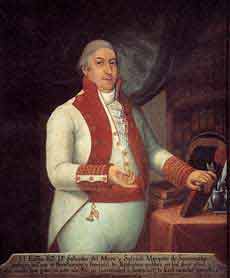
Calle de Someruelos |
Calle Someruelos |
|
Named for the Marquis de Someruelos, Captain-General of
the Spanish Provinces of
This portrait was
painted by Juan del Rio (1748-18??) and is part of the collection of the
Museo Nacional de Bellas Artes de La Habana ( |
|
Calle de los Jardines |
Calle de los Jard(illegible) |
|
'Jardines' is the plural of 'Jardin' = Garden. So correctly this should be anglicized to 'Gardens Street'. Or perhaps it was named for the Jardine family; we know that Isabella Jardine lived here in 1817, although not on Garden Street. |
* Further information on
1. From The Other War of 1812. James G Cusick. 2007
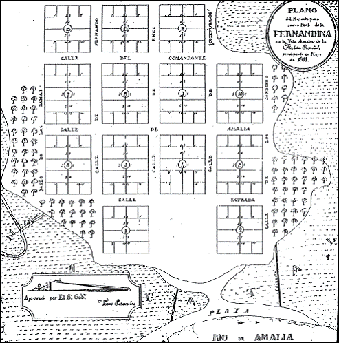
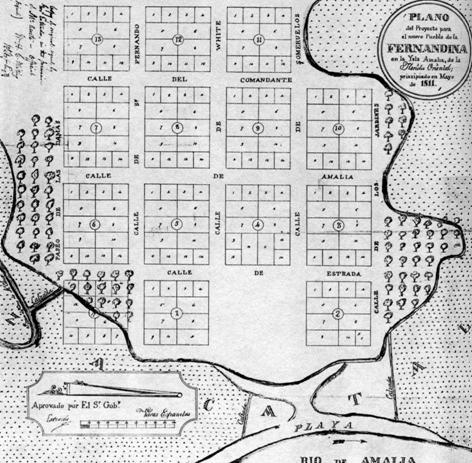
The two maps below are printed in the Old Town Guidelines on pp.5 and 11, but they are rather hard to read. Thanks to Professor Tilson, we have a clearer version of the 1811 map (reproduced below). There are a number of subtle differences between the two 1811 maps, and they suggest that the copy in the Guidelines may be the ‘as-submitted’, while the copy below is the ‘as-approved’ version.
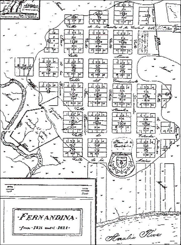
The 1821 map shows the extension of
|
Titled Plat map of Taken
from Old Town Guidelines p.5
Alternative map provided by Prof. W. Tilson. Note Estrada’s signature in the Approval box, and the notes at the top left of the map. |
Map showing lots in Old Town based on Spanish records.
Drawn by Franz Dollheimer in April 1937. This copy appears in Old Town
Guidelines p.11, titled Map of Old Town,
Fernandina, Florida, 1821. |
Last modified March 7, 2021